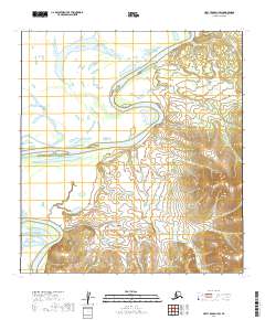
2019 Map of Holy Cross D-1 SW
USGS Topo · Published 2019About this map
The Innoko River dominates this portion of the Alaskan interior, winding through an intricate network of oxbow lakes and wetlands. The river's meandering course across the flat floodplain defines the western half of the landscape, illustrating the dynamic nature of this subarctic waterway. To the east, the terrain rises into the foothills, where tightly packed contour lines reveal a shift from the soggy river valley to more elevated ground. This 2019 survey documents the complex hydrology of the Innoko River basin, a region defined by its isolation and the seasonal rhythms of the water, far from the established road networks of the Yukon-Koyukuk Census Area.
Find a feature on this map
7 named features on this map. Tap any name to fly to it.
Don’t see what you’re looking for? This feature index may not catch every label — zoom into the map to look around manually.
Map Details
Editions of this 2019 Holy Cross D-1 SW Map
This is the sole edition of this map. No revisions or reprints were ever made.
Other maps of this area

1951 · Holy Cross
USGS Topo · 1:250,000

1952 · Holy Cross C-2
USGS Topo · 1:63,360

1952 · Holy Cross C-1
USGS Topo · 1:63,360

1952 · Holy Cross D-2
USGS Topo · 1:63,360

1952 · Holy Cross D-1
USGS Topo · 1:63,360

1952 · Holy Cross
USGS Topo · 1:250,000

2019 · Holy Cross C-1 NE
USGS Topo · 1:25,000
2019 · Holy Cross D-2 NE
USGS Topo · 1:25,000
2019 · Holy Cross D-1 NW
USGS Topo · 1:25,000
2019 · Holy Cross D-1 NE
USGS Topo · 1:25,000