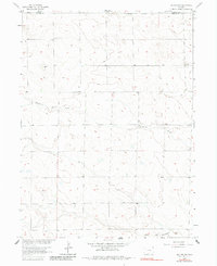
1962 Map of Holyoke NW
USGS Topo · Published 1983About this map
The High Plains of Phillips County are defined by the intermittent drainage patterns of Wildhorse Creek as it winds toward the Sedgwick and Phillips county line. This 1962 topography, updated via photoinspection in 1980, reveals a sparsely settled agricultural landscape where social life centered on the Fairfield Community Hall and religious gatherings at Fairview Ch. The land is scored by the eastern Colorado environment, where water access was managed via localized wells and the seasonal flow of North Fk Frenchman Creek in the south. For local historians and genealogists, the Paoli Cem near the southern boundary serves as a primary record of the families who settled this portion of the Missouri River Basin development area. Beyond the farmsteads and section lines, the presence of a Gravel Pit indicates small-scale local industry supporting the rural road network.
Find a feature on this map
8 named features on this map. Tap any name to fly to it.
Don’t see what you’re looking for? This feature index may not catch every label — zoom into the map to look around manually.
Map Details
Editions of this 1962 Holyoke NW Map
2 editions found
Other maps of this area

1952 · Julesburg SW
USGS Topo · 1:24,000

1952 · Julesburg SE
USGS Topo · 1:24,000

1952 · Marks Butte
USGS Topo · 1:24,000

1954 · Sterling
USGS Topo · 1:250,000

1958 · Sterling
USGS Topo · 1:250,000

1962 · Holyoke NE
USGS Topo · 1:24,000

1962 · Haxtun East
USGS Topo · 1:24,000

1962 · Holyoke NW
USGS Topo · 1:24,000

1971 · Paoli
USGS Topo · 1:24,000

1971 · Holyoke
USGS Topo · 1:24,000