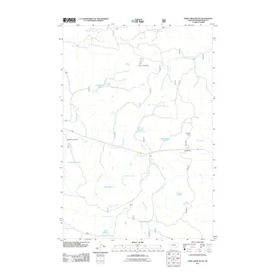
2011 Map of Home Creek Butte
USGS Topo · Published 2011About this map
Home Creek Butte rises as a prominent landmark in this portion of Powder River County, overseeing a landscape defined by an intricate network of drainages and seasonal water sources. The area is characterized by numerous small reservoirs, such as Phillips Reservoir and Tobin Reservoir, which suggest a reliance on water management for livestock or local needs. Named passes like Suicide Pass and Camps Pass indicate established routes through the terrain, while the presence of Schoolhouse Draw points to a history of local community infrastructure. The map documents several named springs, including Lemonade Spring, Hanson Spring, and Cabin Spring, which provided essential water points along the creeks. Drainages like Marvell Creek, Wilbur Creek, and Fly Creek carve through the region, illustrating the complex hydrology of this part of Montana just after the first decade of the 2000s.
Find a feature on this map
41 named features on this map. Tap any name to fly to it.
Don’t see what you’re looking for? This feature index may not catch every label — zoom into the map to look around manually.
Map Details
Editions of this 2011 Home Creek Butte Map
This is the sole edition of this map. No revisions or reprints were ever made.
Other maps of this area

1954 · Hardin
USGS Topo · 1:250,000

1954 · Ekalaka
USGS Topo · 1:250,000

1956 · Ekalaka
USGS Topo · 1:250,000

1957 · Hardin
USGS Topo · 1:250,000

1958 · Ekalaka
USGS Topo · 1:250,000

1958 · Hardin
USGS Topo · 1:250,000

1965 · Ekalaka
USGS Topo · 1:250,000
1966 · Sonnette
USGS Topo · 1:24,000
1966 · Coleman Draw
USGS Topo · 1:24,000
1966 · Stacey
USGS Topo · 1:24,000