
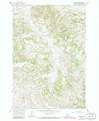
1966 Map of Sonnette
USGS Topo · Published 1969About this map
Sonnette serves as the focal point for this 1960s survey of the Powder River country, where ranching and early mineral exploration shaped the high plains. The landscape is defined by the winding course of Pumpkin Creek and its many tributaries, including Sugar Run and Dry Creek. The map documents the scattered rural infrastructure of the era, from the Mitchell Sch providing education for local ranch families to the Two Tree Mine located near the North Fork Two Tree Creek.
Find a feature on this map
20 named features on this map. Tap any name to fly to it.
Don’t see what you’re looking for? This feature index may not catch every label — zoom into the map to look around manually.
Map Details
Editions of this 1966 Sonnette Map
2 editions found
Other maps of this area

1954 · Ekalaka
USGS Topo · 1:250,000

1956 · Ekalaka
USGS Topo · 1:250,000

1958 · Ekalaka
USGS Topo · 1:250,000

1965 · Ekalaka
USGS Topo · 1:250,000

1966 · Home Creek Butte
USGS Topo · 1:24,000

1966 · Phillips Butte
USGS Topo · 1:24,000

1966 · Hodsdon Flats
USGS Topo · 1:24,000

1966 · Threemile Buttes
USGS Topo · 1:24,000

1966 · Samuelson Ranch
USGS Topo · 1:24,000
1973 · Yarger Butte
USGS Topo · 1:24,000