
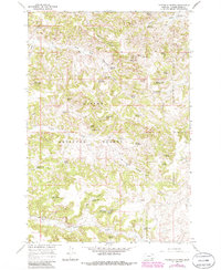
1966 Map of Threemile Buttes
USGS Topo · Published 1969About this map
Custer National Forest encompasses much of this southeastern Montana landscape, where the terrain is defined by an intricate network of drainage gulches and high-country springs. The area shows a specialized ranching and mining economy centered around water access, evidenced by the numerous named water sources like Old Faithful Spring and Joe Yager Spring. Remote outposts such as Phillips Well and structural features like Bowers Reservoir indicate the infrastructure required to manage livestock in the high plains.
Find a feature on this map
50 named features on this map. Tap any name to fly to it.
Don’t see what you’re looking for? This feature index may not catch every label — zoom into the map to look around manually.
Map Details
Editions of this 1966 Threemile Buttes Map
2 editions found
Other maps of this area

1954 · Hardin
USGS Topo · 1:250,000

1954 · Ekalaka
USGS Topo · 1:250,000

1956 · Ekalaka
USGS Topo · 1:250,000

1957 · Hardin
USGS Topo · 1:250,000

1958 · Ekalaka
USGS Topo · 1:250,000

1958 · Hardin
USGS Topo · 1:250,000

1965 · Ekalaka
USGS Topo · 1:250,000

1966 · Goodspeed Butte
USGS Topo · 1:24,000

1966 · Sonnette
USGS Topo · 1:24,000

1966 · Coleman Draw
USGS Topo · 1:24,000