
1966 Map of Goodspeed Butte
USGS Topo · Published 1969About this map
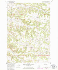
Custer National Forest dominates this mid-1960s landscape in Powder River County, revealing a terrain shaped by the vital necessity of water management in eastern Montana. The map is densely marked with livestock-related infrastructure, including numerous small reservoirs and named springs that sustained the local ranching economy. Features like the Goodspeed Draw Reservoir, Howes Reservoir, and Elk Creek Reservoir No 3 are scattered across the draws and coulees, illustrating how land was utilized within the national forest boundaries. Historical industrial activity is evidenced by labels such as Elk Creek Sawmill Spring and Taylor Creek Sawmill Spring, pointing to localized timber processing near the headwaters of the regional drainage systems. Notable landmarks like Goodspeed Butte and the winding course of Lyon Creek provide geographic anchors for a region defined by its isolated springs and water catchment basins.
Find a feature on this map
47 named features on this map. Tap any name to fly to it.
Don’t see what you’re looking for? This feature index may not catch every label — zoom into the map to look around manually.
Map Details
Editions of this 1966 Goodspeed Butte Map
2 editions found
Other maps of this area

1954 · Hardin
USGS Topo · 1:250,000

1954 · Ekalaka
USGS Topo · 1:250,000

1956 · Ekalaka
USGS Topo · 1:250,000

1957 · Hardin
USGS Topo · 1:250,000

1958 · Ekalaka
USGS Topo · 1:250,000

1958 · Hardin
USGS Topo · 1:250,000

1965 · Ekalaka
USGS Topo · 1:250,000

1966 · Phillips Butte
USGS Topo · 1:24,000

1966 · Fort Howes
USGS Topo · 1:24,000

1966 · Threemile Buttes
USGS Topo · 1:24,000