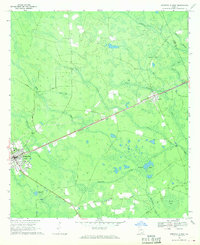
1968 Map of Homerville East
USGS Topo · Published 1970About this map
Homerville and the smaller village of Argyle anchor this survey of the South Georgia flatwoods, where the Seaboard Coast Line railroad creates a rigid diagonal across a landscape defined by wetlands and creek branches. The map illustrates the region's unique geography, characterized by "bays"—shallow, swampy depressions such as Isiac Bay, Bunkle Bay, and Devils Bay—alternating with higher ground like Sandy Flats. This interplay between the linear iron of the railroad and the meandering courses of Suwannee Creek and Cane Creek dictated the placement of early settlements and roads. Local heritage is preserved through the locations of the Clinch Memorial Hospital and rural congregations like New Pine Grove Ch and Shiloh Ch. The abundance of named branches, such as Polly Branch and Martha Branch, reflects the intricate drainage network vital to the local timber and turpentine industries.
Find a feature on this map
34 named features on this map. Tap any name to fly to it.
Don’t see what you’re looking for? This feature index may not catch every label — zoom into the map to look around manually.
Map Details
Editions of this 1968 Homerville East Map
Other maps of this area

1953 · Waycross
USGS Topo · 1:250,000

1954 · Valdosta
USGS Topo · 1:250,000

1958 · Valdosta
USGS Topo · 1:250,000

1958 · Waycross
USGS Topo · 1:250,000

1959 · Valdosta
USGS Topo · 1:250,000

1967 · Spooner
USGS Topo · 1:24,000

1967 · Pine Valley
USGS Topo · 1:24,000

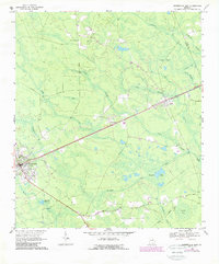
1968 · Homerville East
USGS Topo · 1:24,000

1968 · Midway
USGS Topo · 1:24,000

1968 · Manor
USGS Topo · 1:24,000