1955 Map of Homewood
USGS Topo · Published 1970About this map
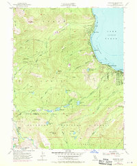
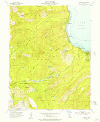
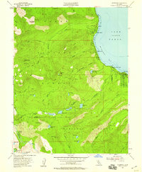
Lake Tahoe dominates the eastern shoreline of this survey, where the development of the mid-20th century is evident in the residential grids of Tahoma and Homewood. While the lakefront is defined by established communities and seasonal retreats like Chambers Lodge, the high backcountry to the west remains a primitive expanse of the Tahoe National Forest and El Dorado National Forest. These mountains are marked by numerous alpine basins holding Quail Lake, Miller Lake, and Richardson Lake, alongside the steep ascent of Ellis Peak. Historical industrial activity is represented by the Noonchester Mine, while the southern reaches preserve the rugged character of the Desolation Wilderness. The map captures the transition between the growing recreational communities along Mc Kinney Bay and the high Sierra Nevada terrain accessed only by the Deep Trail and various jeep tracks.
Find a feature on this map
55 named features on this map. Tap any name to fly to it.
Don’t see what you’re looking for? This feature index may not catch every label — zoom into the map to look around manually.
Map Details
Editions of this 1955 Homewood Map
4 editions found

Other maps of this area

1889 · Pyramid Peak
USGS Topo · 1:125,000

1891 · Truckee
USGS Topo · 1:125,000

1891 · Pyramid Peak
USGS Topo · 1:125,000

1893 · Truckee
USGS Topo · 1:125,000

1895 · Pyramid Peak
USGS Topo · 1:125,000

1895 · Truckee
USGS Topo · 1:125,000

1896 · Pyramid Peak
USGS Topo · 1:125,000

1932 · Truckee
USGS Topo · 1:96,000

1940 · Truckee
USGS Topo · 1:125,000

1947 · Sacramento
USGS Topo · 1:250,000