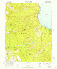
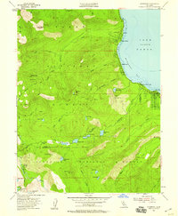
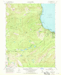
1955 Map of Homewood
USGS Topo · Published 1956About this map
McKinney Bay and the western shores of Lake Tahoe define this mid-century survey, which details the transition from lakeside resort communities to the high wilderness of the Tahoe National Forest. Early development along the shoreline is evident at Homewood, Tahoe Pines, and Chambers Lodge, while the interior remains a landscape of prominent peaks and alpine basins. The map documents the rugged geography leading toward the Eldorado National Forest, featuring high-elevation points like Ellis Peak and Twin Peaks.
Find a feature on this map
51 named features on this map. Tap any name to fly to it.
Don’t see what you’re looking for? This feature index may not catch every label — zoom into the map to look around manually.
Map Details
Editions of this 1955 Homewood Map
4 editions found

Other maps of this area

1889 · Pyramid Peak
USGS Topo · 1:125,000

1891 · Truckee
USGS Topo · 1:125,000

1891 · Pyramid Peak
USGS Topo · 1:125,000

1893 · Truckee
USGS Topo · 1:125,000

1895 · Pyramid Peak
USGS Topo · 1:125,000

1895 · Truckee
USGS Topo · 1:125,000

1896 · Pyramid Peak
USGS Topo · 1:125,000

1932 · Truckee
USGS Topo · 1:96,000

1940 · Truckee
USGS Topo · 1:125,000

1947 · Sacramento
USGS Topo · 1:250,000