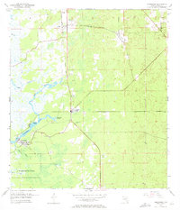
1954 Map of Homosassa
USGS Topo · Published 1972About this map
The Homosassa River and its intricate network of tidal creeks define this coastal Citrus County landscape during the mid-1950s. The settlement of Homosassa serves as a hub near Buzzard Point, while further inland, the developing area around Homosassa Springs shows the transition from the river's edge to the pine and palmetto flatwoods. Transportation history is deeply etched into the terrain, visible through the Atlantic Coast Line tracks and an Old Railroad Grade that speaks to earlier industrial or logging efforts in the region.
Find a feature on this map
19 named features on this map. Tap any name to fly to it.
Don’t see what you’re looking for? This feature index may not catch every label — zoom into the map to look around manually.
Map Details
Editions of this 1954 Homosassa Map
4 editions found
Other maps of this area

1895 · Tsala Apopka
USGS Topo · 1:62,500

1954 · Lecanto
USGS Topo · 1:24,000

1954 · Homosassa
USGS Topo · 1:24,000

1954 · Holder
USGS Topo · 1:24,000

1954 · Chassahowitzka Bay
USGS Topo · 1:24,000

1954 · Crystal River
USGS Topo · 1:24,000

1954 · Brooksville NW
USGS Topo · 1:24,000

1954 · Chassahowitzka
USGS Topo · 1:24,000

1954 · Red Level
USGS Topo · 1:24,000

1954 · Ozello
USGS Topo · 1:24,000