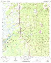
1954 Map of Homosassa
USGS Topo · Published 1988About this map
The Homosassa River and its intricate network of tidal creeks dominate this mid-century survey of coastal Citrus County. The landscape is defined by the convergence of Halls River, Otter Creek, and Salt Creek as they flow toward the Gulf, with the prominent Buzzard Point marking a sharp bend in the main channel. Settlement is concentrated around the thermal waters of Homosassa Springs and the established town of Homosassa.
Find a feature on this map
28 named features on this map. Tap any name to fly to it.
Don’t see what you’re looking for? This feature index may not catch every label — zoom into the map to look around manually.
Map Details
Editions of this 1954 Homosassa Map
4 editions found
Other maps of this area

1895 · Tsala Apopka
USGS Topo · 1:62,500

1954 · Lecanto
USGS Topo · 1:24,000

1954 · Homosassa
USGS Topo · 1:24,000

1954 · Holder
USGS Topo · 1:24,000

1954 · Chassahowitzka Bay
USGS Topo · 1:24,000

1954 · Crystal River
USGS Topo · 1:24,000

1954 · Brooksville NW
USGS Topo · 1:24,000

1954 · Chassahowitzka
USGS Topo · 1:24,000

1954 · Red Level
USGS Topo · 1:24,000

1954 · Ozello
USGS Topo · 1:24,000