
1984 Map of Hooper
USGS Topo · Published 1985About this map
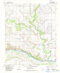
Red River defines the southern boundary of this region where the borders of Oklahoma and Texas meet. The landscape is marked by the branching waters of Whiskey Creek and Cache, which carve through the plains north of the river. Small settlements like Hooper and the eastern edge of Hastings provide a glimpse into the rural community structure of the late 1970s and early 1980s. A notable local landmark is the Pleasant Ridge Community Ctr, serving the scattered farmsteads across the undulating terrain. The eastern portion of the map includes the Hastings Cemetery and the prominent Bourland rise. Several oil or water wells are indicated throughout the territory, suggesting the local reliance on subterranean resources for both agriculture and industry during this period.
Find a feature on this map
18 named features on this map. Tap any name to fly to it.
Don’t see what you’re looking for? This feature index may not catch every label — zoom into the map to look around manually.
Map Details
Editions of this 1984 Hooper Map
This is the sole edition of this map. No revisions or reprints were ever made.
Other maps of this area

1955 · Lawton
USGS Topo · 1:250,000

1957 · Hastings
USGS Topo · 1:62,500

1957 · Randlett
USGS Topo · 1:62,500

1962 · Walters
USGS Topo · 1:62,500

1962 · Temple
USGS Topo · 1:62,500
1972 · Charlie
USGS Topo · 1:24,000
1984 · Irving
USGS Topo · 1:24,000
1984 · Petrolia
USGS Topo · 1:24,000
1984 · Waurika West
USGS Topo · 1:24,000
1985 · Taylor
USGS Topo · 1:24,000