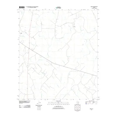
2010 Map of Hope
USGS Topo · Published 2010About this map
The settlement of Hope anchors this portion of Lavaca County, situated amidst a dense network of watercourses that feed the Lavaca River to the east. This 2010 survey illustrates a predominantly rural landscape defined by ranch roads and significant drainages, including the lengthy paths of Clarks Creek and Big Brushy Creek. For local historians and genealogists, the presence of the Harless Cemetery and its namesake Harless Cemetary Rd provides a specific point of interest in the northern half of the quadrangle. The terrain is characterized by numerous small branches and creeks, such as Scarboroughs Branch and Waterhole Creek, which reveal the hydrological patterns of the region. The map captures the enduring rural character of this Texas landscape, where the road network follows the natural contours of the many intersecting creek beds like Boggy Creek and Supplejack Creek.
Find a feature on this map
27 named features on this map. Tap any name to fly to it.
Don’t see what you’re looking for? This feature index may not catch every label — zoom into the map to look around manually.
Map Details
Editions of this 2010 Hope Map
This is the sole edition of this map. No revisions or reprints were ever made.
Other maps of this area

1953 · Seguin
USGS Topo · 1:250,000

1958 · Seguin
USGS Topo · 1:250,000

1962 · Terryville
USGS Topo · 1:24,000

1962 · Hallettsville SE
USGS Topo · 1:24,000

1963 · Fordtran
USGS Topo · 1:24,000

1963 · Sweet Home
USGS Topo · 1:24,000

1964 · Morales
USGS Topo · 1:24,000
1964 · Navidad
USGS Topo · 1:24,000

1964 · Ezzell
USGS Topo · 1:24,000

1965 · Hope
USGS Topo · 1:24,000