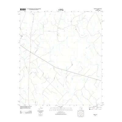
2013 Map of Hope
USGS Topo · Published 2013About this map
Hope serves as the primary settlement on this Texas landscape, situated within a dense network of watercourses that define the regional geography. The eastern edge is bounded by the Lavaca River, while the interior is partitioned by numerous creeks including Supplejack Cr, Clarks Cr, and Big Brushy Cr. These drainage patterns likely influenced the early road and settlement development throughout Lavaca County.
Find a feature on this map
32 named features on this map. Tap any name to fly to it.
Don’t see what you’re looking for? This feature index may not catch every label — zoom into the map to look around manually.
Map Details
Editions of this 2013 Hope Map
This is the sole edition of this map. No revisions or reprints were ever made.
Other maps of this area

1953 · Seguin
USGS Topo · 1:250,000

1958 · Seguin
USGS Topo · 1:250,000

1962 · Terryville
USGS Topo · 1:24,000

1962 · Hallettsville SE
USGS Topo · 1:24,000

1963 · Fordtran
USGS Topo · 1:24,000

1963 · Sweet Home
USGS Topo · 1:24,000

1964 · Morales
USGS Topo · 1:24,000
1964 · Navidad
USGS Topo · 1:24,000

1964 · Ezzell
USGS Topo · 1:24,000

1965 · Hope
USGS Topo · 1:24,000