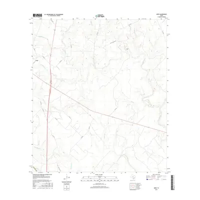
2016 Map of Hope
USGS Topo · Published 2016About this map
Hope serves as the primary landmark in this rural pocket of Lavaca County, where a dense network of county roads and creek systems defines the cattle and agricultural landscape. The map reveals a drainage pattern dominated by the Lavaca River and its numerous tributaries, including Supplejack Creek and Waterhole Creek. For genealogists, the inclusion of Harless Cem along Harless Cemetary Rd provides a specific point of interest for family history research in this part of Texas. The settlement pattern is sparse, with small clusters of structures linked by routes like Dry Hollow Rd and Co Rd 438, reflecting a modern era where the land remains largely open and used for ranching. Natural features such as Scarboroughs Br and Bear Br suggest the localized geography that has influenced road placements for generations.
Find a feature on this map
33 named features on this map. Tap any name to fly to it.
Don’t see what you’re looking for? This feature index may not catch every label — zoom into the map to look around manually.
Map Details
Editions of this 2016 Hope Map
This is the sole edition of this map. No revisions or reprints were ever made.
Other maps of this area

1953 · Seguin
USGS Topo · 1:250,000

1958 · Seguin
USGS Topo · 1:250,000

1962 · Terryville
USGS Topo · 1:24,000

1962 · Hallettsville SE
USGS Topo · 1:24,000

1963 · Fordtran
USGS Topo · 1:24,000

1963 · Sweet Home
USGS Topo · 1:24,000

1964 · Morales
USGS Topo · 1:24,000
1964 · Navidad
USGS Topo · 1:24,000

1964 · Ezzell
USGS Topo · 1:24,000

1965 · Hope
USGS Topo · 1:24,000