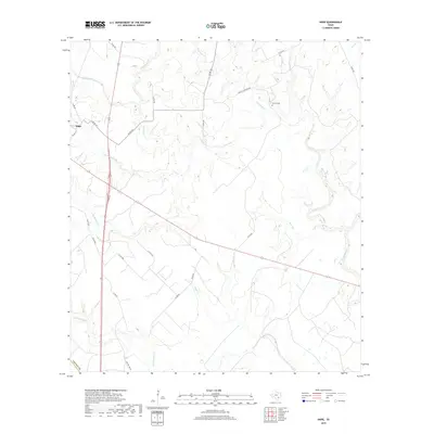
2019 Map of Hope
USGS Topo · Published 2019About this map
Hope serves as the primary landmark in this rural landscape of southeastern Texas, situated amidst a dense network of tributaries that feed into the Lavaca River. The terrain is defined by a complex drainage system, including Clarks Cr, Waterhole Cr, and Supplejack Cr, which have shaped the local topography and historical road patterns. This survey reflects the persistence of long-established land divisions and property lines that follow the winding paths of these waterways rather than a rigid grid.
Find a feature on this map
33 named features on this map. Tap any name to fly to it.
Don’t see what you’re looking for? This feature index may not catch every label — zoom into the map to look around manually.
Map Details
Editions of this 2019 Hope Map
This is the sole edition of this map. No revisions or reprints were ever made.
Other maps of this area

1953 · Seguin
USGS Topo · 1:250,000

1958 · Seguin
USGS Topo · 1:250,000

1962 · Terryville
USGS Topo · 1:24,000

1962 · Hallettsville SE
USGS Topo · 1:24,000

1963 · Fordtran
USGS Topo · 1:24,000

1963 · Sweet Home
USGS Topo · 1:24,000

1964 · Morales
USGS Topo · 1:24,000
1964 · Navidad
USGS Topo · 1:24,000

1964 · Ezzell
USGS Topo · 1:24,000

1965 · Hope
USGS Topo · 1:24,000