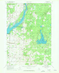
1969 Map of Hope
USGS Topo · Published 1972About this map
Wixom Lake and the Tittabawassee River anchor this late-1960s landscape, illustrating the recreational and residential growth occurring along the shoreline in northern Midland County. Settlements like All Bright Shores and Lockwood Beach highlight the era's lakeside development, supported by the All Bright Shores Landing Field for local aviation. Away from the water, the interior of Hope township remains defined by its agricultural and civic roots, with the Hillside Sch and several country cemeteries, including New Hope Cem and the original Hope Cem, serving as critical touchstones for family historians.
Find a feature on this map
54 named features on this map. Tap any name to fly to it.
Don’t see what you’re looking for? This feature index may not catch every label — zoom into the map to look around manually.
Map Details
Editions of this 1969 Hope Map
This is the sole edition of this map. No revisions or reprints were ever made.
Other maps of this area

1934 · Sanford
USGS Topo · 1:62,500

1936 · Sanford
USGS Topo · 1:62,500

1954 · Midland
USGS Topo · 1:250,000

1958 · Midland
USGS Topo · 1:250,000

1959 · Midland
USGS Topo · 1:250,000

1962 · Midland North
USGS Topo · 1:24,000

1966 · Midland
USGS Topo · 1:250,000

1969 · Gladwin
USGS Topo · 1:24,000
1969 · Bentley
USGS Topo · 1:24,000
1969 · Edenville
USGS Topo · 1:24,000