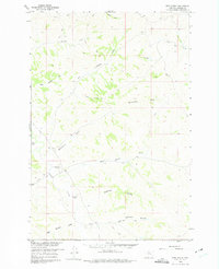
1960 Map of Hope Ranch
USGS Topo · Published 1975About this map
Hope Ranch and Anderson Ranch serve as the primary human touchpoints in this 1960 survey of rural Treasure County. The landscape is defined by an intricate network of seasonal drainages and coulees, where water management is evident through features like Spillway 3350 and a system of unimproved trails and jeep paths. This area, mapped for the development of the Missouri River Basin, reveals a quiet intersection of cattle ranching and early energy exploration, marked by an Oil Well and a small Airstrip near the southern coulees. The terrain is deeply etched by Big Lightning Creek and Hutchinson Creek, showing the natural erosion patterns that define the local geography. Local history researchers can trace the specific boundaries and infrastructure of these mid-century operations, from the Gravel Pit near Jasper Coulee to the remote reaches of Thunder Creek.
Find a feature on this map
20 named features on this map. Tap any name to fly to it.
Don’t see what you’re looking for? This feature index may not catch every label — zoom into the map to look around manually.
Map Details
Editions of this 1960 Hope Ranch Map
2 editions found
Other maps of this area

1954 · Hardin
USGS Topo · 1:250,000

1954 · Forsyth
USGS Topo · 1:250,000

1957 · Hardin
USGS Topo · 1:250,000

1957 · Forsyth
USGS Topo · 1:250,000

1958 · Forsyth
USGS Topo · 1:250,000

1958 · Hardin
USGS Topo · 1:250,000

1960 · Bighorn
USGS Topo · 1:24,000

1960 · Marsh Coulee
USGS Topo · 1:24,000

1960 · Eldering Ranch
USGS Topo · 1:24,000

1960 · Hope Ranch
USGS Topo · 1:24,000