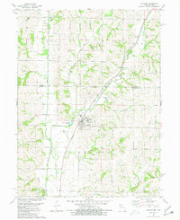
1980 Map of Hopkins
USGS Topo · Published 1981About this map
The One Hundred and Two River winds southward through this 1980 survey of the borderlands between Missouri and Iowa, defining the drainage patterns of northwestern Nodaway Co. The town of Hopkins serves as the central hub of this agricultural landscape, situated where the Burlington Northern railroad corridor meets the river valley. The terrain is marked by significant topographical landmarks such as The Mound and is dissected by several watercourses including Beard Branch, Slaughter Branch, and Brushy Creek.
Find a feature on this map
28 named features on this map. Tap any name to fly to it.
Don’t see what you’re looking for? This feature index may not catch every label — zoom into the map to look around manually.
Map Details
Editions of this 1980 Hopkins Map
This is the sole edition of this map. No revisions or reprints were ever made.
Other maps of this area

1940 · Bedford
USGS Topo · 1:62,500

1940 · New Market
USGS Topo · 1:62,500

1940 · Parnell
USGS Topo · 1:62,500

1943 · Bedford
USGS Topo · 1:62,500

1943 · Parnell
USGS Topo · 1:62,500

1943 · Maryville
USGS Topo · 1:62,500

1943 · New Market
USGS Topo · 1:62,500

1955 · Nebraska City
USGS Topo · 1:250,000

1957 · Nebraska City
USGS Topo · 1:250,000

1958 · Nebraska City
USGS Topo · 1:250,000