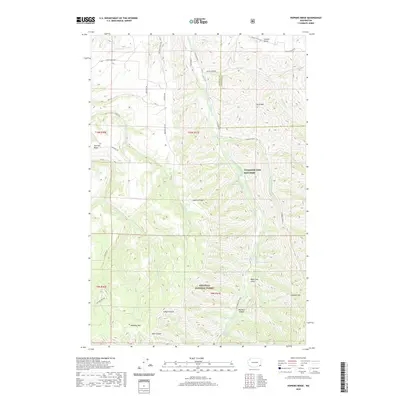
2020 Map of Hopkins Ridge
USGS Topo · Published 2020About this map
The Tucannon River carves a deep valley through this corner of southeast Washington, where the high plateaus of Hopkins Ridge and Starvout Ridge overlook a complex network of canyons and gulches. The landscape is defined by the transition from agricultural uplands into the protected wilderness of the Umatilla National Forest. A notable concentration of water resources exists along the river corridor, including the Tucannon Fish Hatchery and a series of small alpine bodies such as Rainbow Lake, Blue Lake, and Deer Lake.
Find a feature on this map
44 named features on this map. Tap any name to fly to it.
Don’t see what you’re looking for? This feature index may not catch every label — zoom into the map to look around manually.
Map Details
Editions of this 2020 Hopkins Ridge Map
This is the sole edition of this map. No revisions or reprints were ever made.
Other maps of this area

1937 · Pomeroy
USGS Topo · 1:96,000

1942 · Pomeroy
USGS Topo · 1:125,000

1955 · Pullman
USGS Topo · 1:250,000

1958 · Pullman
USGS Topo · 1:250,000

1967 · Rose Springs
USGS Topo · 1:24,000

1967 · Hopkins Ridge
USGS Topo · 1:24,000

1967 · Cahill Mtn
USGS Topo · 1:24,000
1967 · Pomeroy
USGS Topo · 1:24,000

1967 · Stentz Spring
USGS Topo · 1:24,000

1967 · Turner
USGS Topo · 1:24,000