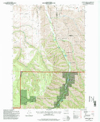
1995 Map of Hopkins Ridge
USGS Topo · Published 1998About this map
Tucannon River flows through a deep valley corridor in this mid-1990s survey of the Blue Mountains region, where state and federal conservation efforts define the land use. The valley floor contains a string of recreational and management sites within the W. T. Wooten Wildlife Area, including Spring Lake, Rainbow Lake, and a Fish Hatchery. The map captures the transition from these managed wildlife zones into the more primitive terrain of the Umatilla National Forest to the south.
Find a feature on this map
26 named features on this map. Tap any name to fly to it.
Don’t see what you’re looking for? This feature index may not catch every label — zoom into the map to look around manually.
Map Details
Editions of this 1995 Hopkins Ridge Map
This is the sole edition of this map. No revisions or reprints were ever made.
Other maps of this area

1937 · Pomeroy
USGS Topo · 1:96,000

1942 · Pomeroy
USGS Topo · 1:125,000

1955 · Pullman
USGS Topo · 1:250,000

1958 · Pullman
USGS Topo · 1:250,000

1967 · Rose Springs
USGS Topo · 1:24,000

1967 · Hopkins Ridge
USGS Topo · 1:24,000

1967 · Cahill Mtn
USGS Topo · 1:24,000
1967 · Pomeroy
USGS Topo · 1:24,000

1967 · Stentz Spring
USGS Topo · 1:24,000

1967 · Turner
USGS Topo · 1:24,000