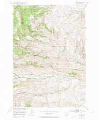
1951 Map of Hoppers
USGS Topo · Published 1974About this map
Industrial decline and mountain transit define this Park County landscape in the early 1950s. The southern portion of the map is dominated by the remnants of a once-active mining economy, specifically at Cokedale (Aband). Evidence of this former activity is preserved through labels for the Cokedale Mines No 2 (Aband), a Mine Dump, and the Cokedale School (Aband). These features sit along the valley floor near the headwaters of Billman Creek.
Find a feature on this map
19 named features on this map. Tap any name to fly to it.
Don’t see what you’re looking for? This feature index may not catch every label — zoom into the map to look around manually.
Map Details
Editions of this 1951 Hoppers Map
5 editions found
Other maps of this area

1891 · Livingston
USGS Topo · 1:250,000

1893 · Livingston
USGS Topo · 1:250,000

1947 · Bozeman
USGS Topo · 1:250,000

1948 · Bozeman
USGS Topo · 1:250,000

1951 · Bozeman Pass
USGS Topo · 1:62,500

1951 · Gobblers Knob
USGS Topo · 1:24,000

1951 · Chadborn
USGS Topo · 1:24,000

1951 · Brisbin
USGS Topo · 1:24,000

1951 · Hoppers
USGS Topo · 1:24,000

1951 · Chimney Rock
USGS Topo · 1:24,000