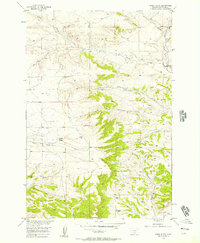
1956 Map of Horse Butte
USGS Topo · Published 1957About this map
Horse Butte rises as a central landmark in this mid-1950s survey of Stillwater County terrain, where the drainage patterns of the North Fork Cottonwood Creek and South Fork Cottonwood Creek carve through the landscape. The map reveals early industrial activity at a Strip Mine located in the northwest, contrasting with the numerous Springs and named watercourses like Swamp Creek and Tilden Creek that define the area's hydrology. Elevation data is anchored by the VABM Peterson 4419 survey station, while the southern reach shows the engineered path of the Cove Ditch. This document captures the intersection of natural watershed geography and the beginning of resource extraction in the Missouri River Basin development era.
Find a feature on this map
17 named features on this map. Tap any name to fly to it.
Don’t see what you’re looking for? This feature index may not catch every label — zoom into the map to look around manually.
Map Details
Editions of this 1956 Horse Butte Map
2 editions found
Other maps of this area

1892 · Stillwater
USGS Topo · 1:125,000

1954 · Billings
USGS Topo · 1:250,000

1956 · Hunter Lake
USGS Topo · 1:24,000

1956 · Shane Ridge
USGS Topo · 1:24,000

1956 · Horse Butte
USGS Topo · 1:24,000

1956 · Molt
USGS Topo · 1:24,000

1956 · Columbus East
USGS Topo · 1:24,000

1956 · Rapids
USGS Topo · 1:24,000

1956 · Park City
USGS Topo · 1:24,000
1956 · Wheat Basin SW
USGS Topo · 1:24,000