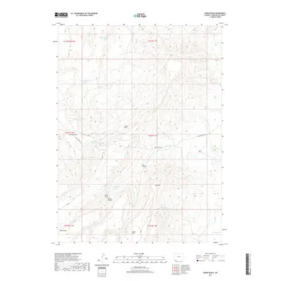
2017 Map of Horse Ranch
USGS Topo · Published 2017About this map
Horse Ranch sits at the center of a complex high-desert landscape in Sweetwater County, defined by a network of seasonal water management and distinct geological formations. The terrain is deeply incised by East Canyon, West Canyon, and Middle Canyon, which drain into the broad expanse of Big Hollow Cr. Ranching infrastructure is evident through numerous reservoirs designed to capture runoff across the arid flats and benches, including Staley Corral Reservoir, Calamagrostis Reservoir, and Green Sandstone Reservoir. The presence of Cedar Mtn and Mass Mtn provides significant vertical relief, while Big Hollow Bench and Cattail Draw illustrate the varied drainage patterns of this Wyoming rangeland. Navigation through the area is facilitated by primitive routes like Cedar Mountain Rd and Rim Rd.
Find a feature on this map
26 named features on this map. Tap any name to fly to it.
Don’t see what you’re looking for? This feature index may not catch every label — zoom into the map to look around manually.
Map Details
Editions of this 2017 Horse Ranch Map
This is the sole edition of this map. No revisions or reprints were ever made.
Other maps of this area

1954 · Ogden
USGS Topo · 1:250,000

1954 · Rock Springs
USGS Topo · 1:250,000

1958 · Ogden
USGS Topo · 1:250,000

1958 · Rock Springs
USGS Topo · 1:250,000

1960 · Ogden
USGS Topo · 1:250,000

1962 · Rock Springs
USGS Topo · 1:250,000

1964 · Butcher Knife Draw
USGS Topo · 1:24,000
1964 · Mc Kinnon
USGS Topo · 1:24,000

1964 · Soap Holes Reservoir
USGS Topo · 1:24,000

1964 · Black Spring Reservoir
USGS Topo · 1:24,000