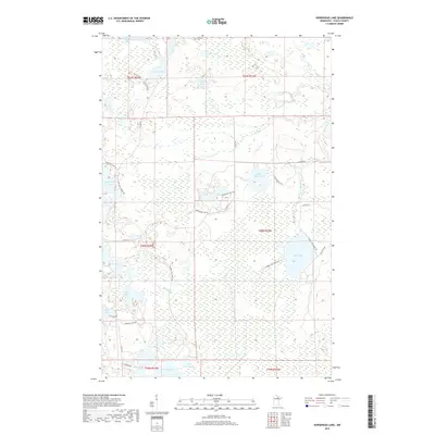
2019 Map of Horsehead Lake
USGS Topo · Published 2019About this map
Bear River winds through this section of Itasca County, defining a landscape of interconnected wetlands and timbered tracts. The terrain is characterized by numerous small lakes, from the northern waters of Rat Lake and Eve Lake to the southern reaches of Wasson Lake. Navigational routes are largely comprised of specialized forestry and lake access roads, such as Horsehead Lake Trl and Wilson Lk Forest Rd, reflecting the area's use for timber management and outdoor recreation. The map provides a detailed view of the complex hydrography in the Chippewa National Forest region, where smaller bodies like Napoleon Lake and Tuber Lake are separated by narrow ridges. This network of forest roads and trails, including E Bear Lake Forest Rd and Wasson Lake Forest Rd, illustrates the localized transportation patterns essential for accessing these remote Minnesota watersheds.
Find a feature on this map
39 named features on this map. Tap any name to fly to it.
Don’t see what you’re looking for? This feature index may not catch every label — zoom into the map to look around manually.
Map Details
Editions of this 2019 Horsehead Lake Map
This is the sole edition of this map. No revisions or reprints were ever made.
Other maps of this area

1919 · Release
USGS Topo · 1:62,500

1943 · Release
USGS Topo · 1:62,500

1954 · Hibbing
USGS Topo · 1:250,000

1957 · Hibbing
USGS Topo · 1:250,000

1958 · Hibbing
USGS Topo · 1:250,000

1964 · Hibbing
USGS Topo · 1:250,000

1964 · Sherry Lake
USGS Topo · 1:24,000
1964 · O'Leary Lake
USGS Topo · 1:24,000

1970 · Deer Lake East
USGS Topo · 1:24,000
1970 · Anderson Lake
USGS Topo · 1:24,000