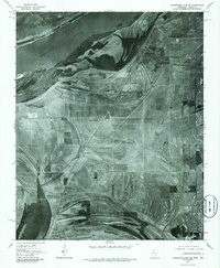
1975 Map of Horseshoe Lake SE
USGS Topo · Published 1986About this map
Robinsonville and its surrounding agricultural landscape are captured in this mid-1970s orthophotomap, showing the delta as it appeared decades before it became a major gaming and tourism destination. The imagery reveals the complex relationship between the land and the Mississippi River, where former river channels and oxbow-like scarring indicate the shifting path of the water over centuries. This specific era shows the region as a purely rural economy, defined by geometric field patterns and small clusters of buildings. Transport and commerce are tied to the Illinois Central Gulf railroad line, which connects the small settlements of Penton, Clack, and Bowdre across the flat alluvial plain. The orthophoto format provides an exceptionally clear view of farm infrastructure and historical road alignments during a period of agricultural stability.
Find a feature on this map
6 named features on this map. Tap any name to fly to it.
Don’t see what you’re looking for? This feature index may not catch every label — zoom into the map to look around manually.
Map Details
Editions of this 1975 Horseshoe Lake SE Map
2 editions found
Other maps of this area

1908 · Hollywood
USGS Topo · 1:24,000

1908 · Lake Cormorant
USGS Topo · 1:24,000

1912 · Lake Cormorant
USGS Topo · 1:31,680

1913 · Hollywood
USGS Topo · 1:31,680

1931 · Horseshoe Lake
USGS Topo · 1:62,500

1932 · Horn Lake
USGS Topo · 1:48,000

1932 · Crenshaw
USGS Topo · 1:62,500

1935 · Crenshaw
USGS Topo · 1:62,500

1935 · Horn Lake
USGS Topo · 1:62,500

1939 · Clayton
USGS Topo · 1:62,500