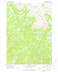
1968 Map of Horseshoe Lake
USGS Topo · Published 1976About this map
Mount Baldy and Round Top Mountain anchor the high alpine terrain of the Bridger Wilderness within the Bridger National Forest. Surveyed in the late 1960s, this landscape is defined by an intricate network of glacial basins and high-elevation waters including Horseshoe Lake, Lake George, and Timico Lake. The presence of the Highline Trail and the Timico Trail reveals the established backcountry routes used by hikers and packers to navigate the granite peaks and lake-dotted valleys. From the northern Chain Lakes down to Lake Ethel and Blueberry Lake in the south, the map documents a pristine watershed where drainage flows through Baldy Creek and Fall Creek toward Boulder Canyon. The concentration of named lakes like Lake Christina, Lake Winona, and Coyote Lake suggests a geography shaped by heavy glaciation, preserved at a time when these remote reaches of Sublette County were being formally mapped for modern recreational use.
Find a feature on this map
43 named features on this map. Tap any name to fly to it.
Don’t see what you’re looking for? This feature index may not catch every label — zoom into the map to look around manually.
Map Details
Editions of this 1968 Horseshoe Lake Map
4 editions found
Other maps of this area

1909 · Fremont Peak
USGS Topo · 1:125,000

1938 · Mt Bonneville
USGS Topo · 1:62,500

1941 · Mt Bonneville
USGS Topo · 1:62,500

1942 · Mt Bonneville
USGS Topo · 1:62,500

1952 · Alpine Lake
USGS Topo · 1:24,000

1955 · Thermopolis
USGS Topo · 1:250,000

1955 · Lander
USGS Topo · 1:250,000

1958 · Lander
USGS Topo · 1:250,000

1958 · Thermopolis
USGS Topo · 1:250,000

1961 · Lander
USGS Topo · 1:250,000