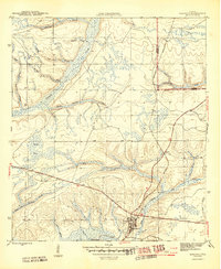
1945 Map of Hosford
USGS Topo · Published 1945About this map
Hosford serves as the primary settlement and transportation hub in this mid-1940s landscape, positioned where the Apalachicola Northern railroad cuts through the Panhandle pine woods. The terrain is defined by an intricate network of waterways, including the winding Telogia Creek and Ocklawaha Creek, which dictate the local topography and historical movement through the region. Land divisions are clearly marked by the prominent east-west Base Line, a fundamental surveying marker for Florida land lines.
Find a feature on this map
21 named features on this map. Tap any name to fly to it.
Don’t see what you’re looking for? This feature index may not catch every label — zoom into the map to look around manually.
Map Details
Editions of this 1945 Hosford Map
3 editions found
Other maps of this area

1943 · Lake Talquin
USGS Topo · 1:62,500

1945 · Hosford
USGS Topo · 1:31,680

1945 · Bristol
USGS Topo · 1:31,680

1945 · Woods
USGS Topo · 1:31,680

1945 · Telogia
USGS Topo · 1:24,000

1946 · Telogia
USGS Topo · 1:31,680

1954 · Tallahassee
USGS Topo · 1:250,000

1955 · Rock Bluff
USGS Topo · 1:24,000

1955 · Sycamore
USGS Topo · 1:24,000

1959 · Tallahassee
USGS Topo · 1:250,000