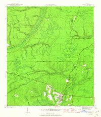
1945 Map of Hosford
USGS Topo · Published 1960About this map
Hosford serves as the primary hub of this North Florida landscape, situated where the Apalachicola Northern railroad cuts through the heavy timberlands and wetlands of Liberty County. The mapping reveals a complex network of waterways, including the winding Telogia Creek, Big Creek, and the curiously named Bumpy Bay, which define the local drainage patterns. North of the settlement, the Base Line provides a rigid cartographic contrast to the organic flow of White Panther Creek and Double Gin Branch.
Find a feature on this map
23 named features on this map. Tap any name to fly to it.
Don’t see what you’re looking for? This feature index may not catch every label — zoom into the map to look around manually.
Map Details
Editions of this 1945 Hosford Map
3 editions found
Other maps of this area

1943 · Lake Talquin
USGS Topo · 1:62,500

1945 · Hosford
USGS Topo · 1:31,680

1945 · Bristol
USGS Topo · 1:31,680

1945 · Woods
USGS Topo · 1:31,680

1945 · Telogia
USGS Topo · 1:24,000

1946 · Telogia
USGS Topo · 1:31,680

1954 · Tallahassee
USGS Topo · 1:250,000

1955 · Rock Bluff
USGS Topo · 1:24,000

1955 · Sycamore
USGS Topo · 1:24,000

1959 · Tallahassee
USGS Topo · 1:250,000