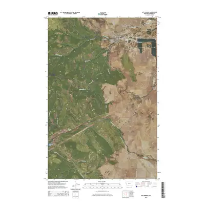
2014 Map of Hot Springs
USGS Topo · Published 2014About this map
Hot Springs and the nearby settlement of Camas occupy a notable geothermal and agricultural landscape in Sanders County. The local hydrology is defined by Hot Springs Cr and the complex irrigation of the Camas Canal, which feeds the surrounding ranching and farming operations. Family and community heritage are anchored by local burial grounds, including Maillet Cem, Ventling Cem, and Moore Cem, providing valuable points of reference for genealogists.
Find a feature on this map
80 named features on this map. Tap any name to fly to it.
Don’t see what you’re looking for? This feature index may not catch every label — zoom into the map to look around manually.
Map Details
Editions of this 2014 Hot Springs Map
This is the sole edition of this map. No revisions or reprints were ever made.
Other maps of this area

1956 · Wallace
USGS Topo · 1:250,000

1959 · Perma
USGS Topo · 1:62,500

1959 · Plains
USGS Topo · 1:62,500

1960 · Wallace
USGS Topo · 1:250,000

1964 · Markle Pass
USGS Topo · 1:24,000

1964 · Coney Peak
USGS Topo · 1:24,000

1964 · Baldy Lake
USGS Topo · 1:24,000

1964 · Lonepine
USGS Topo · 1:24,000

1964 · Hot Springs
USGS Topo · 1:24,000
1964 · Hot Springs NE
USGS Topo · 1:24,000