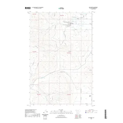
2020 Map of Hot Springs
USGS Topo · Published 2020About this map
Hot Springs and the nearby settlement of Camas sit within a complex hydrological landscape defined by both natural thermal features and engineered water systems. The town grid of Hot Springs is clearly delineated, with local landmarks such as Maillet Cem and various street names providing a detailed view of the community's layout. To the east, the Camas Prairie Basin opens up, where the Camas Canal and Warm Springs Cr intersect a region dotted with historic burial grounds including Venting Cem and Moore Cem. The terrain is marked by prominent elevations like Burke Hill and Markle Hill, while the drainage of Hot Springs Cr and Cottonwood Cr shapes the valley floor. Researchers can trace the sophisticated water management of the area through features like Toolman Slough and multiple named springs, reflecting the region's long-standing relationship with its unique groundwater resources.
Find a feature on this map
82 named features on this map. Tap any name to fly to it.
Don’t see what you’re looking for? This feature index may not catch every label — zoom into the map to look around manually.
Map Details
Editions of this 2020 Hot Springs Map
This is the sole edition of this map. No revisions or reprints were ever made.
Other maps of this area

1956 · Wallace
USGS Topo · 1:250,000

1959 · Perma
USGS Topo · 1:62,500

1959 · Plains
USGS Topo · 1:62,500

1960 · Wallace
USGS Topo · 1:250,000

1964 · Markle Pass
USGS Topo · 1:24,000

1964 · Coney Peak
USGS Topo · 1:24,000

1964 · Baldy Lake
USGS Topo · 1:24,000

1964 · Lonepine
USGS Topo · 1:24,000

1964 · Hot Springs
USGS Topo · 1:24,000
1964 · Hot Springs NE
USGS Topo · 1:24,000