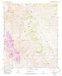
1964 Map of Hot Tamale Peak
USGS Topo · Published 1982About this map
Mining operations and cattle ranching define this section of the Dripping Spring Mountains in the mid-1960s. The landscape is dominated by the industrial footprint of the Ray Mine and Calumet Mine, which contrast sharply with the established rural structures like the Slash S Ranch and Troy Ranch. Significant topographical landmarks such as Hot Tamale Peak and Tiger Mtn rise above a complex network of canyons and washes, including Hackberry Gulch and Stone Cabin Wash. This survey is particularly valuable for documenting the locations of Ray (Site) and Sonora (Site), appearing here as identified sites rather than active towns. A dedicated Railroad and numerous substations support the heavy extraction activity centered around Sonora Hill and the Twin Domes, while high-altitude springs like Woodchopper Spring and Laguna Spring reveal the vital water sources required to sustain both industry and homesteads in this arid environment.
Find a feature on this map
67 named features on this map. Tap any name to fly to it.
Don’t see what you’re looking for? This feature index may not catch every label — zoom into the map to look around manually.
Map Details
Editions of this 1964 Hot Tamale Peak Map
3 editions found
Other maps of this area

1900 · Florence
USGS Topo · 1:125,000

1901 · Globe
USGS Topo · 1:62,500

1902 · Globe
USGS Topo · 1:62,500

1902 · Florence
USGS Topo · 1:125,000

1910 · Ray
USGS Topo · 1:62,500

1948 · Pinal Ranch
USGS Topo · 1:24,000

1948 · Superior
USGS Topo · 1:62,500

1948 · Superior
USGS Topo · 1:24,000

1949 · Pinal Ranch
USGS Topo · 1:24,000

1949 · Superior
USGS Topo · 1:24,000