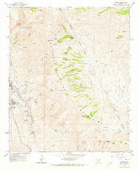
1964 Map of Sonora
USGS Topo · Published 1973About this map
Industrial activity and ranching define the landscape of the Dripping Spring Mountains in the mid-1960s. The bustling operations at Ray and the nearby settlement of Sonora are documented just south of Mineral Creek, showcasing the significant infrastructure required for the Ray Mine. This includes a complex network of roads, substations, and a dedicated railroad line serving the mineral extraction sites. To the east, the terrain transitions into a series of spring-fed gulches and canyons, where several historical ranching sites like Troy Ranch and Slash S Ranch are located near the Gila and Pinal county boundary.
Find a feature on this map
67 named features on this map. Tap any name to fly to it.
Don’t see what you’re looking for? This feature index may not catch every label — zoom into the map to look around manually.
Map Details
Editions of this 1964 Sonora Map
3 editions found
Other maps of this area

1900 · Florence
USGS Topo · 1:125,000

1901 · Globe
USGS Topo · 1:62,500

1902 · Globe
USGS Topo · 1:62,500

1902 · Florence
USGS Topo · 1:125,000

1910 · Ray
USGS Topo · 1:62,500

1948 · Pinal Ranch
USGS Topo · 1:24,000

1948 · Superior
USGS Topo · 1:62,500

1948 · Superior
USGS Topo · 1:24,000

1949 · Pinal Ranch
USGS Topo · 1:24,000

1949 · Superior
USGS Topo · 1:24,000