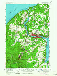
1954 Map of Houghton
USGS Topo · Published 1964About this map
Houghton and its industrial surroundings serve as the focal point of this copper country survey, showcasing the dense mining infrastructure of the Keweenaw Peninsula. The Copper Range is traced through a series of company towns and active workings, including Atlantic Mine, Trimountain, and Painesdale, where the Champion Mine remains a prominent fixture of the landscape. Along the shores of Portage Lake, the Michigan College of Mining and Technology anchors the educational and technical hub of the region, while the Duluth South Shore and Atlantic railroad facilitates the heavy transport required for the local economy. From the coastal recreation at McLain State Park on Lake Superior to the inland farms near Liminga and Oskar, the map illustrates a complex geography of resource extraction and established community life. Researchers will find significant detail in the placement of local institutions like the County Hospital and the remote Tri-mountain Lookout Tower.
Find a feature on this map
80 named features on this map. Tap any name to fly to it.
Don’t see what you’re looking for? This feature index may not catch every label — zoom into the map to look around manually.
Map Details
Editions of this 1954 Houghton Map
2 editions found

Other maps of this area

1915 · Houghton
USGS Topo · 1:62,500

1941 · Ahmeek
USGS Topo · 1:31,680

1946 · Hancock
USGS Topo · 1:24,000

1946 · Chassell
USGS Topo · 1:24,000

1946 · South Range
USGS Topo · 1:24,000

1946 · Muggun Creek
USGS Topo · 1:24,000

1946 · Ahmeek
USGS Topo · 1:24,000

1946 · Laurium
USGS Topo · 1:24,000

1947 · Ahmeek
USGS Topo · 1:24,000

1948 · South Range
USGS Topo · 1:24,000