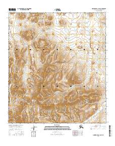
2016 Map of Howard Pass C-4 SW
USGS Topo · Published 2016About this map
The Cockscomb dominates the northwestern heights of this North Slope landscape, serving as a prominent topographic anchor in a region defined by high-altitude drainages and complex ridgelines. The terrain is characterized by a series of high basins where Swayback Cr begins its descent through the central sections of the survey area. To the south, the headwaters of the Kuna River emerge, reflecting the fundamental hydrology of the Brooks Range foothills before these waters flow north toward the Arctic coastal plain. The map detail highlights the intricate contouring of the land, illustrating how the natural topography dictates the path of seasonal melt and perennial streams. This 2016 record from the U.S. Geological Survey captures the primitive state of the wilderness within the North Slope Borough, where lack of human infrastructure leaves the physical geography as the primary narrative of the land.
Find a feature on this map
9 named features on this map. Tap any name to fly to it.
Don’t see what you’re looking for? This feature index may not catch every label — zoom into the map to look around manually.
Map Details
Editions of this 2016 Howard Pass C-4 SW Map
This is the sole edition of this map. No revisions or reprints were ever made.
Other maps of this area

1951 · Howard Pass
USGS Topo · 1:250,000

1956 · Howard Pass
USGS Topo · 1:250,000
1984 · Howard Pass C-5
USGS Topo · 1:63,360

1984 · Howard Pass B-4
USGS Topo · 1:63,360

1984 · Howard Pass C-4
USGS Topo · 1:63,360
1984 · Howard Pass B-5
USGS Topo · 1:63,360
2015 · Howard Pass C-5 SE
USGS Topo · 1:25,000
2015 · Howard Pass B-5 NE
USGS Topo · 1:25,000
2016 · Howard Pass B-4 NW
USGS Topo · 1:25,000
2016 · Howard Pass C-5 NE
USGS Topo · 1:25,000