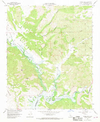
1967 Map of Huasna Peak
USGS Topo · Published 1968About this map
Huasna Valley serves as the central artery of this Central Coast landscape, where the confluence of the Huasna River and Alamo Creek meet the Twitchell Reservoir. The map documents a mid-century period of rural land use, dominated by large family holdings such as the Porter Ranch, Oakley Ranch, and Swickard Ranch. The rugged eastern portion of the sheet is defined by the Los Padres National Forest, a network of canyons including Haystack Canyon and Stephens Canyon punctuated by the Deer Trail Mine. To the south, the county line between San Luis Obispo and Santa Barbara counties cuts across the Cuyama River near Vaquero Flat. The prevalence of gaging stations and land subject to controlled inundation reflects the era's focus on water management and reservoir development in the semi-arid canyon country.
Find a feature on this map
31 named features on this map. Tap any name to fly to it.
Don’t see what you’re looking for? This feature index may not catch every label — zoom into the map to look around manually.
Map Details
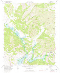
Editions of this 1967 Huasna Peak Map
2 editions found
Other maps of this area

1905 · Lompoc
USGS Topo · 1:125,000

1922 · Nipomo
USGS Topo · 1:62,500

1937 · Branch Mtn
USGS Topo · 1:48,000

1942 · Lompoc
USGS Topo · 1:125,000

1942 · Santa Maria
USGS Topo · 1:62,500

1942 · Branch Mountain
USGS Topo · 1:62,500

1942 · Tepusquet Peak
USGS Topo · 1:62,500

1943 · Tepusquet Peak
USGS Topo · 1:62,500

1943 · Lompoc
USGS Topo · 1:125,000
1947 · Los Coches Mtn
USGS Topo · 1:24,000