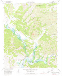
1967 Map of Huasna Peak
USGS Topo · Published 1980About this map
Huasna Valley and the surrounding coastal range highlands are depicted here during a period of water management and land preservation in the late 1960s. The northern reaches of Twitchell Reservoir dominate the low-lying drainage basins where the Huasna River, Alamo Creek, and Cuyama River converge. The terrain is marked by established cattle operations such as Porter Ranch, Oakley Ranch, and Swiekert Ranch, illustrating the region's long-standing ranching tradition. Much of the eastern and northern landscape falls within the Los Padres National Forest, where a network of primitive tracks leads to isolated landmarks like the Deer Trail Mine. Notable summits including Huasna Peak, Stanley Mtn, and Boar Peak define the local topography, while features like Vaquero Flat and Tunnel Flat indicate the varied plateaus used for grazing and transit between the rugged canyons.
Find a feature on this map
33 named features on this map. Tap any name to fly to it.
Don’t see what you’re looking for? This feature index may not catch every label — zoom into the map to look around manually.
Map Details
Editions of this 1967 Huasna Peak Map
2 editions found
Other maps of this area

1905 · Lompoc
USGS Topo · 1:125,000

1922 · Nipomo
USGS Topo · 1:62,500

1937 · Branch Mtn
USGS Topo · 1:48,000

1942 · Lompoc
USGS Topo · 1:125,000

1942 · Santa Maria
USGS Topo · 1:62,500

1942 · Branch Mountain
USGS Topo · 1:62,500

1942 · Tepusquet Peak
USGS Topo · 1:62,500

1943 · Tepusquet Peak
USGS Topo · 1:62,500

1943 · Lompoc
USGS Topo · 1:125,000
1947 · Los Coches Mtn
USGS Topo · 1:24,000