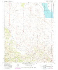
1959 Map of Chimineas Ranch
USGS Topo · Published 1989About this map
Carrizo Plain ranching operations and the expansive Soda Lake basin define this corner of San Luis Obispo County during the mid-20th century. The landscape is marked by a series of significant family holdings and outposts, including Chimineas Ranch, Goodwin Ranch, and American Ranch. These sites are linked by a network of unimproved roads and specialized infrastructure like the Goodwin Ranch Airport and various Landing Strips, reflecting the necessity of air travel for managing isolated desert tracts.
Find a feature on this map
31 named features on this map. Tap any name to fly to it.
Don’t see what you’re looking for? This feature index may not catch every label — zoom into the map to look around manually.
Map Details
Editions of this 1959 Chimineas Ranch Map
Other maps of this area

1912 · McKittrick
USGS Topo · 1:125,000

1932 · La Panza
USGS Topo · 1:48,000

1935 · La Panza
USGS Topo · 1:62,500

1936 · La Panza
USGS Topo · 1:62,500

1937 · Branch Mtn
USGS Topo · 1:48,000

1941 · Caliente Mountain
USGS Topo · 1:62,500

1942 · Branch Mountain
USGS Topo · 1:62,500

1942 · Caliente Mtn
USGS Topo · 1:62,500

1943 · Simmler
USGS Topo · 1:62,500

1943 · Caliente Mtn.
USGS Topo · 1:62,500