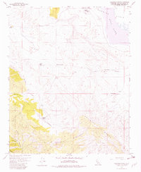
1959 Map of Chimineas Ranch
USGS Topo · Published 1980About this map
Chimineas Ranch and its neighboring agricultural outposts define this corner of the California interior during the late 1950s. The landscape is characterized by a transition from the level expanse of the Carrizo Plain and the edge of Soda Lake in the north to the rising elevations of the Caliente Range and the Los Padres National Forest in the south. This era shows a network of remote ranching operations, including Goodwin Ranch and American Ranch, often accompanied by private landing strips and critical water sources like Turkey Camp Well. The presence of several springs and the drainage of Barrett Creek illustrate the vital importance of water management in this arid environment. Traces of early industrial activity are seen at a mine and a jeep trail winding through Saltos Canyon, providing evidence of how these high-desert lands were navigated and utilized.
Find a feature on this map
21 named features on this map. Tap any name to fly to it.
Don’t see what you’re looking for? This feature index may not catch every label — zoom into the map to look around manually.
Map Details
Editions of this 1959 Chimineas Ranch Map
Other maps of this area

1912 · McKittrick
USGS Topo · 1:125,000

1932 · La Panza
USGS Topo · 1:48,000

1935 · La Panza
USGS Topo · 1:62,500

1936 · La Panza
USGS Topo · 1:62,500

1937 · Branch Mtn
USGS Topo · 1:48,000

1941 · Caliente Mountain
USGS Topo · 1:62,500

1942 · Branch Mountain
USGS Topo · 1:62,500

1942 · Caliente Mtn
USGS Topo · 1:62,500

1943 · Simmler
USGS Topo · 1:62,500

1943 · Caliente Mtn.
USGS Topo · 1:62,500