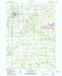
1962 Map of Hudson
USGS Topo · Published 1979About this map
The city of Hudson serves as the focal point for this region of Lenawee County, where the New York Central rail line reflects the area's transition toward the end of the twentieth century. While the line through town is noted as abandoned, the landscape remains defined by its agricultural and civic foundations, including the Lincoln Sch, High Sch, and the Athletic Field. To the east, the creation of Lake Hudson at a normal pool elevation of 841 feet represents a significant man-made alteration to the drainage patterns of Bear Creek and Henning Drain.
Find a feature on this map
55 named features on this map. Tap any name to fly to it.
Don’t see what you’re looking for? This feature index may not catch every label — zoom into the map to look around manually.
Map Details
Editions of this 1962 Hudson Map
3 editions found
Other maps of this area

1911 · Wauseon
USGS Topo · 1:62,500

1913 · Wauseon
USGS Topo · 1:62,500

1913 · Alvordton
USGS Topo · 1:62,500

1943 · Wauseon
USGS Topo · 1:62,500

1944 · Alvordton
USGS Topo · 1:62,500

1953 · Fort Wayne
USGS Topo · 1:250,000

1956 · Fort Wayne
USGS Topo · 1:250,000

1960 · Morenci
USGS Topo · 1:24,000

1960 · Fayette
USGS Topo · 1:24,000
1961 · Alvordton
USGS Topo · 1:24,000