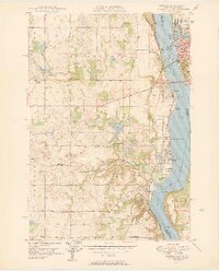
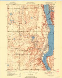
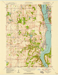
1950 Map of Hudson
USGS Topo · Published 1950About this map
Hudson and its neighboring riverfront communities sit at a critical intersection of rail and water transport along the St Croix River at the dawn of the 1950s. This survey details the developed shoreline from North Hudson down to Afton, connected by the Toll Bridge and serviced by both the Chicago and North Western and Chicago Milwaukee St Paul and Pacific railroads. The industrial footprint of the era is evident at the Power Plant and Dam on Lake Mallalieu, while the surrounding rural townships of Oakdale, Baytown, and Troy are dotted with one-room schoolhouses and country churches.
Find a feature on this map
42 named features on this map. Tap any name to fly to it.
Don’t see what you’re looking for? This feature index may not catch every label — zoom into the map to look around manually.
Map Details
Editions of this 1950 Hudson Map
2 editions found
Other maps of this area

1946 · Hudson
USGS Topo · 1:62,500

1946 · River Falls
USGS Topo · 1:62,500

1948 · New Richmond
USGS Topo · 1:62,500

1948 · Stillwater
USGS Topo · 1:62,500

1949 · New Richmond
USGS Topo · 1:62,500

1949 · River Falls
USGS Topo · 1:62,500

1949 · Hudson
USGS Topo · 1:62,500

1949 · Stillwater
USGS Topo · 1:62,500

1949 · Lake Elmo
USGS Topo · 1:24,000
1949 · Hudson
USGS Topo · 1:24,000