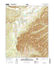
2016 Map of Hughes A-1 SW
USGS Topo · Published 2016About this map
Indian River flows through the southern reaches of this interior Alaskan landscape, defining the local drainage patterns alongside Notoniono Cr and Oithgidunka Cr. This 2016 survey highlights a vast, unpopulated stretch of the Yukon-Koyukuk region where the topography transitions from low-lying wetlands and complex stream meanders to significant upland ridges. The mapping of township and range lines, including t8n r26e and t7n r26e, provides a formal grid over an area otherwise characterized by natural watercourses and the seasonal movement of water across the tundra. The intricate contour work reveals the elevation changes that guide these tributary systems toward larger river basins in the Alaskan bush.
Find a feature on this map
9 named features on this map. Tap any name to fly to it.
Don’t see what you’re looking for? This feature index may not catch every label — zoom into the map to look around manually.
Map Details
Editions of this 2016 Hughes A-1 SW Map
This is the sole edition of this map. No revisions or reprints were ever made.
Other maps of this area

1951 · Hughes
USGS Topo · 1:250,000

1951 · Melozitna
USGS Topo · 1:250,000

1952 · Melozitna D-1
USGS Topo · 1:63,360

1955 · Melozitna D-2
USGS Topo · 1:63,360

1955 · Hughes A-2
USGS Topo · 1:63,360

1955 · Hughes A-1
USGS Topo · 1:63,360

1956 · Hughes
USGS Topo · 1:250,000

1956 · Melozitna
USGS Topo · 1:250,000
1956 · Hughes A-2
USGS Topo · 1:63,360

1964 · Hughes
USGS Topo · 1:250,000