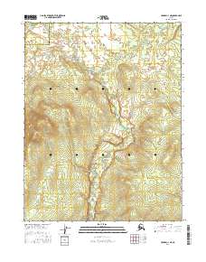
2016 Map of Hughes C-3 NE
USGS Topo · Published 2016About this map
The Hogatza River meanders southward through this interior Alaskan wilderness, carving a distinct valley through the public land survey system grids. The landscape is defined by the administrative boundary of the Northwest Arctic Borough Yukon-Koyukuk Census Area, a division that marks the transition between two of the state’s largest remote regions. This 2016 survey illustrates the intricate drainage patterns of the river and its unnamed tributaries as they navigate the varied elevations of the area. Map researchers will find precise township and range designations, including t16n r21e, t15n r22e, and t14n r21e, which provide the essential spatial framework for land status and geographical study in this unpopulated reach of the Alaskan interior.
Find a feature on this map
8 named features on this map. Tap any name to fly to it.
Don’t see what you’re looking for? This feature index may not catch every label — zoom into the map to look around manually.
Map Details
Editions of this 2016 Hughes C-3 NE Map
This is the sole edition of this map. No revisions or reprints were ever made.
Other maps of this area

1951 · Hughes
USGS Topo · 1:250,000

1956 · Hughes
USGS Topo · 1:250,000

1964 · Hughes
USGS Topo · 1:250,000

1965 · Hughes
USGS Topo · 1:250,000
1986 · Hughes C-3
USGS Topo · 1:63,360
1986 · Hughes D-3
USGS Topo · 1:63,360
1986 · Hughes D-2
USGS Topo · 1:63,360
1986 · Hughes C-2
USGS Topo · 1:63,360
2016 · Hughes D-3 SW
USGS Topo · 1:25,000
2016 · Hughes C-2 NW
USGS Topo · 1:25,000