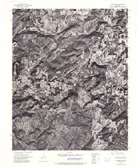
1972 Map of Hulbert SE
USGS Topo · Published 1974About this map
Redberry Mountain and the winding course of Bayou Manard define this Oklahoma landscape during the early 1970s. This orthophotomap, produced by the U.S. Geological Survey and the Oklahoma Geological Survey, provides an aerial perspective on the rural terrain of Cherokee County. The imagery reveals a mosaic of dense woodlands and cleared agricultural fields, showing the local land-use patterns of the era. The southern portion of the quadrangle is marked by the drainage of Greenleaf Creek, while Bob Tail Creek cuts through the northern elevations. Unlike traditional topographic maps, this aerial mosaic allows for the direct observation of field boundaries and tree lines as they existed in late 1972.
Find a feature on this map
4 named features on this map. Tap any name to fly to it.
Don’t see what you’re looking for? This feature index may not catch every label — zoom into the map to look around manually.
Map Details
Editions of this 1972 Hulbert SE Map
This is the sole edition of this map. No revisions or reprints were ever made.
Other maps of this area

1898 · Tahlequah
USGS Topo · 1:125,000

1901 · Muscogee
USGS Topo · 1:125,000

1901 · Tahlequah
USGS Topo · 1:125,000

1905 · Muscogee
USGS Topo · 1:125,000

1905 · Tahlequah
USGS Topo · 1:125,000

1946 · Fort Smith
USGS Topo · 1:250,000

1948 · Hulbert
USGS Topo · 1:62,500

1948 · Webbers Falls
USGS Topo · 1:62,500

1950 · Hulbert
USGS Topo · 1:62,500

1950 · Webbers Falls
USGS Topo · 1:62,500