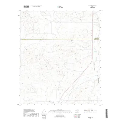
2019 Map of Hulldale
USGS Topo · Published 2019About this map
The S Concho River and its accompanying drainage systems define the high plateau landscape of this region on the border of Tom Green and Schleicher counties. This survey reflects the sparse ranching and hydraulic character of the West Texas plains, where water access remains the primary driver of development. The small settlement of Hulldale sits at a crossroads near the river, while landmarks like Tenmile Waterhole and Hackberry Waterhole indicate critical natural water sources in an otherwise arid environment. Evidence of historical transportation is visible in the alignment of the Old Mt Hwy, which runs parallel to modern routes through the undulating terrain. Significant topographic features like Big Hill stand out against the draws, including Bois D'Arc Draw and Indian Draw, which funnel seasonal runoff toward the Concho basin.
Find a feature on this map
16 named features on this map. Tap any name to fly to it.
Don’t see what you’re looking for? This feature index may not catch every label — zoom into the map to look around manually.
Map Details
Editions of this 2019 Hulldale Map
This is the sole edition of this map. No revisions or reprints were ever made.
Other maps of this area

1892 · San Angelo
USGS Topo · 1:125,000

1893 · Fort McKavett
USGS Topo · 1:125,000

1895 · Sherwood
USGS Topo · 1:125,000

1954 · Sonora
USGS Topo · 1:250,000

1954 · San Angelo
USGS Topo · 1:250,000

1958 · Sonora
USGS Topo · 1:250,000

1958 · San Angelo
USGS Topo · 1:250,000

1963 · Adams NW
USGS Topo · 1:24,000

1964 · Eldorado NW
USGS Topo · 1:24,000
1964 · Eldorado NE
USGS Topo · 1:24,000