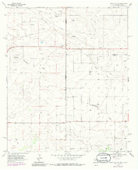
1969 Map of Humble City NE
USGS Topo · Published 1985About this map
Wards Draw cuts across this high plains landscape at the intersection of the Texas and New Mexico state line during the late 1960s. The map illustrates a region transitioning from ranching to intensive industrial extraction, anchored by the Tex Pac Oil Field and numerous Oil Wells dotting the terrain. Evidence of earlier infrastructure is present at the Airport (Abandoned), while the modern era is represented by a Substa and an Aqueduct. Local land use is further characterized by the presence of the Waits Ranch and scattered Gravel Pits, providing a detailed view of the Lea, Yoakum, and Gaines county boundaries as they were surveyed in 1969.
Find a feature on this map
13 named features on this map. Tap any name to fly to it.
Don’t see what you’re looking for? This feature index may not catch every label — zoom into the map to look around manually.
Map Details
Editions of this 1969 Humble City NE Map
4 editions found
Other maps of this area

1954 · Hobbs
USGS Topo · 1:250,000

1954 · Brownfield
USGS Topo · 1:250,000

1958 · Brownfield
USGS Topo · 1:250,000

1958 · Hobbs
USGS Topo · 1:250,000

1962 · Brownfield
USGS Topo · 1:250,000

1969 · Humble City
USGS Topo · 1:24,000

1969 · Humble City NE
USGS Topo · 1:24,000

1969 · Humble City SE
USGS Topo · 1:24,000

1970 · Prairieview
USGS Topo · 1:24,000

1970 · Prairieview SE
USGS Topo · 1:24,000