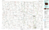
1984 Map of Humboldt
USGS Topo · Published 1992About this map
The Des Moines River valley serves as the central artery for this 1980s landscape, connecting the twin cities of Humboldt and Dakota City with several riverfront recreation areas. The surrounding terrain is defined by an extensive network of drainage infrastructure, such as Ditch No 112 and Ditch No 121, which transformed these prairie lands into productive agriculture. Conservation efforts are highly visible throughout the quadrangle, notably at the Kalsow Prairie State Wildlife Management Area, one of the few remaining fragments of unplowed tallgrass prairie in the state.
Find a feature on this map
119 named features on this map. Tap any name to fly to it.
Don’t see what you’re looking for? This feature index may not catch every label — zoom into the map to look around manually.
Map Details
Editions of this 1984 Humboldt Map
2 editions found

Other maps of this area
1923 · Lehigh
USGS Topo · 1:62,500

1923 · Fort Dodge
USGS Topo · 1:62,500

1954 · Fairmont
USGS Topo · 1:250,000

1954 · Mason City
USGS Topo · 1:250,000

1954 · Waterloo
USGS Topo · 1:250,000

1954 · Fort Dodge
USGS Topo · 1:250,000

1955 · Waterloo
USGS Topo · 1:250,000

1957 · Fort Dodge
USGS Topo · 1:250,000

1957 · Mason City
USGS Topo · 1:250,000

1958 · Mason City
USGS Topo · 1:250,000