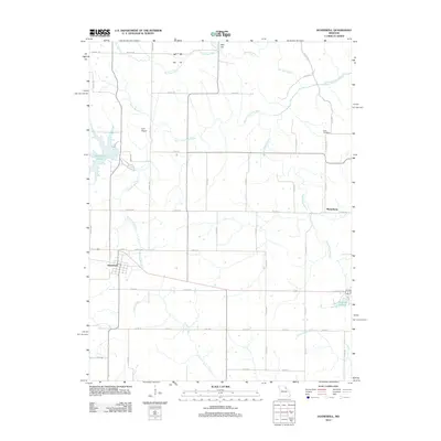
2012 Map of Hunnewell
USGS Topo · Published 2012About this map
Hunnewell serves as the primary hub of this eastern Missouri landscape, where local agriculture meets a network of vital waterways. The town's grid sits just south of Hunnewell Lake, while the smaller settlement of Sharpsburg lies to the east near the Sharpsburg Branch. The terrain is defined by the winding course of the South Fork North River, which is joined by numerous tributaries including Browne Branch, Sherry Branch, and Pee Dee Creek. Local history is anchored by sites like How Cemetery and the notable Deer Lick landmark. To the south, the drainage of Indian Creek and Little Indian Creek shapes the lower quadrangle, while Lyell Airport provides a small aviation footprint in this largely rural expanse near Monroe Lake.
Find a feature on this map
59 named features on this map. Tap any name to fly to it.
Don’t see what you’re looking for? This feature index may not catch every label — zoom into the map to look around manually.
Map Details
Editions of this 2012 Hunnewell Map
This is the sole edition of this map. No revisions or reprints were ever made.
Other maps of this area

1903 · Palmyra
USGS Topo · 1:125,000

1948 · Quincy
USGS Topo · 1:250,000

1949 · Philadelphia
USGS Topo · 1:24,000

1950 · Philadelphia
USGS Topo · 1:24,000

1956 · Quincy
USGS Topo · 1:250,000

1959 · Monroe City
USGS Topo · 1:24,000

1959 · Lakenan
USGS Topo · 1:24,000

1959 · Joanna
USGS Topo · 1:24,000

1959 · Hunnewell
USGS Topo · 1:24,000
1960 · Goss
USGS Topo · 1:24,000