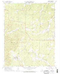
1968 Map of Hunter
USGS Topo · Published 1969About this map
Hunter sits at the convergence of the North Prong Little Black River and the Little Black River, serving as a central point in this late-1960s survey of Carter County. The landscape is defined by the legacy of industry and transport, where an Old Railroad Grade winds through the hills past the Copper Mine and several other unnamed mines. Further east, the settlement of Ellsinore marks the edge of the Clark National Forest, a terrain of narrow valleys like Big Grassy Valley and Horseshoe Valley.
Find a feature on this map
46 named features on this map. Tap any name to fly to it.
Don’t see what you’re looking for? This feature index may not catch every label — zoom into the map to look around manually.
Map Details
Editions of this 1968 Hunter Map
2 editions found
Other maps of this area

1932 · Piedmont
USGS Topo · 1:62,500

1934 · Williamsville
USGS Topo · 1:48,000

1935 · Piedmont
USGS Topo · 1:62,500

1940 · Williamsville
USGS Topo · 1:62,500

1943 · Ellington
USGS Topo · 1:62,500

1944 · Grandin
USGS Topo · 1:62,500

1945 · Ellington
USGS Topo · 1:62,500

1946 · Grandin
USGS Topo · 1:62,500

1949 · Rolla
USGS Topo · 1:250,000

1953 · Rolla
USGS Topo · 1:250,000