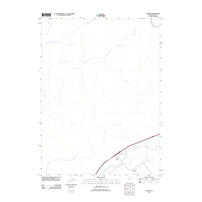
2012 Map of Hunter
USGS Topo · Published 2012About this map
The Humboldt River and its southern fork converge in the southeastern corner of this Nevada landscape, anchoring the small settlement of Hunter. This high-desert terrain is defined by an intricate network of seasonal drainages, including the branching systems of Susie Creek, Middle Susie Creek, and Dry Susie Creek. Water sources are vital in this arid environment, marked by features such as Upper Dry Susie Spring and East Adobe Creek in the northern reaches. Settlement patterns reflect the ranching history of Elko County, centered around the Hunter Banks Ranch near the river. Transportation is dominated by the modern corridor of Interstate 80, which passes through the Hunter Interchange and connects the area via the Frontage RD. This survey captures the essential geography of the Great Basin, where life and travel are dictated by the rare presence of year-round water.
Find a feature on this map
11 named features on this map. Tap any name to fly to it.
Don’t see what you’re looking for? This feature index may not catch every label — zoom into the map to look around manually.
Map Details
Editions of this 2012 Hunter Map
This is the sole edition of this map. No revisions or reprints were ever made.
Other maps of this area

1952 · Dixie Flats
USGS Topo · 1:62,500

1952 · Carlin
USGS Topo · 1:62,500

1955 · Winnemucca
USGS Topo · 1:250,000

1955 · Elko
USGS Topo · 1:250,000

1957 · Elko West
USGS Topo · 1:24,000

1958 · Winnemucca
USGS Topo · 1:250,000

1958 · Elko
USGS Topo · 1:250,000

1958 · Hunter
USGS Topo · 1:24,000

1958 · Huntsman Ranch
USGS Topo · 1:24,000

1958 · Doby Summit
USGS Topo · 1:24,000